

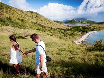
On-Island Hikes
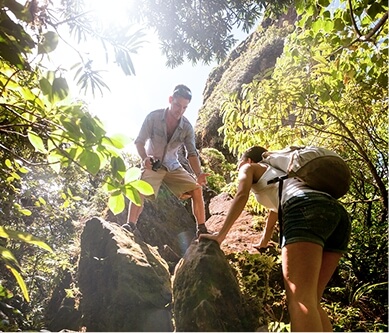
Awake your sense of wander on a bucket list hike that takes your St. Kitts adventure to all-new heights! Clocking in at just under 3,800 feet, Mount Liamuiga is the highest point in St. Kitts and Nevis and one of the tallest peaks in the Caribbean. Naturally, no trip to the Federation is complete without hiking the rim of this dormant volcanic crater. If you’re wondering how long it takes to hike Mount Liamuiga, rest easy. The hike is relatively short, taking only three or four hours to complete. The day of your hike, wear long pants and hiking boots, and bring plenty of water. Departing from Newton Ground in Saint Paul Capisterre Parish, this out-and-back trail heads a few miles away from the coast, climbing through the Kittitian rainforest.
360-DEGREE SPLENDOR
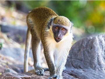
The rainforest, part of Central Forest Reserve National Park, makes for beautiful hiking. Along the way to Mount Liamuiga's peak, you might spot hummingbirds; see soursop, banana trees, and other tropical plants; and, if you’re lucky, come face-to-face with one of St. Kitts’ famous vervet monkeys. The trail can be strenuous, but trust us — with the right guide, it’s well worth the effort.

After a final climb, you’ll come across the best view on St. Kitts. From atop Mount Liamuiga’s rim, you'll enjoy a number of sights: the volcano’s crater, with the Devil's Tooth rising up from the floor; the Caribbean Sea; and the neighboring islands of Saba, Saint Eustatius, Saint Barthélemy, and Saint Martin. If you’re feeling brave, descend via rope into the crater itself and go for a soak in the lake before hiking back to town.
Interested in this experience, or in hiking another of St. Kitts’ trails? We highly recommend hiring a local guide. These guides love the land, and are excited to share St. Kitts’ best hikes with you.
Our Favorite Hiking Trails
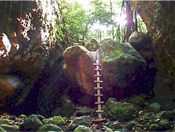
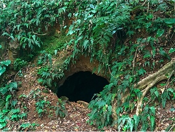
Bat Cave and Waterfall
| Location: | Bloody River, Stonefort |
| Difficulty: | 7/10 |
With its ascending trail and tricky climbs, Bat Cave presents a stiff, but enjoyable, challenge. From its beginning next to an old railroad bridge, this route follows the path of the Bloody River, leading hikers through verdant woods and into the mountains that define St. Kitts. Within 20 minutes of setting off, trekkers must negotiate “The Rock,” a 15-foot boulder that completely blocks the riverbed. Pass this obstacle, though, and you’ll be rewarded with a trip to Bat Cave, home to hundreds of flying bats and a small waterfall.
Mt. Liamuiga Crater Rim
| Location: | Fahies, Newton Ground |
| Time: | Crater Rim and Return: 3-4 hours |
| Difficulty: | 7/10 |
Conquer St. Kitts’ tallest peak. Departing from Newton Ground, this roundtrip route takes 3-4 hours to finish, and cuts through the Kittitian rainforest. Climbing up Mt. Liamuiga’s slopes, hikers will be treated to the sights and sounds of a tropical jungle — the calls of birds, the chatter of vervet monkeys, the shady canopies of exotic trees. The true prize, however, awaits at the summit. Take in the view from the volcano’s rim; if you’re feeling brave, descend via rope into the heart of Mt. Liamuiga, and go for a soak in the crater’s lake before heading back to town.
Dos d'Anse Pond
| Location: | Wingfield, Old Road |
| Time: | 5 Hours |
| Difficulty: | 5/10 |
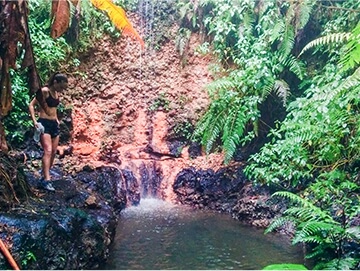
Those searching for a challenge needn’t look further. Clocking in at five hours, the hike up to Dos d’Anse Pond is one of the island’s toughest, sitting some 3,061 feet above sea level. Starting from Old Road Town, the trail rapidly begins climbing through rich, green foliage. The greatest test — a muddy scramble up a 900-foot, 25-degree gutter — comes just before the summit; those who succeed will come across a gorgeous freshwater pond surrounded by tropical plants. A small waterfall cascades nearby, serving as the perfect place to recover before the trek down.
Lawyer Stephen's Cave and Waterfalls
| Location: | Olivees |
| Time: | 3 hours, with extension 5 hours |
| Difficulty: | 5/10 |
Named after James Stephen — a British abolitionist who fought to end the slave trade — this two-part hike sets off from the foot of Olivees Mountain and plunges into the rainforest. The trail slowly climbs 1,339 feet, linking up with a riverbed on the way. A cave sits along a marked trail; continue onward, and you’ll happen across the first of two waterfalls. From here, the choice is yours: Turn back, or tackle an advanced hike, complete with scrambling, rope climbing, and rock hopping, to reach the second cascade. Whichever option you choose, you’ll be back at basecamp within five hours.
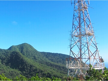
Radio Tower
| Location: | West Farm |
| Time: | 2 to 3 hours roundtrip to the Radio Tower |
| Difficulty: | 4/10 |
Searching for a satisfying trek, but don’t want to spend all day on a trail? Consider the Radio Tower. From your starting point in West Farm, this brisk hike takes roughly 2-3 hours to complete. Twisting and turning up a 1,800-foot climb, the trail provides plenty of shade on its way to the summit. But just because it’s short on length doesn’t mean it’s short on views; the summit reveals a panoramic scene. St. Kitts’ radio tower dominates the foreground, with an undulating, tree-covered ridge defining the landscape behind. Pause for a photo-op before making your way back down.
Shitten Bay
| Location: | Major’s Bay, South East Peninsula |
| Time: | Approximately 1 hour each way |
| Difficulty: | 3/10 |
Wildlife. Shipwrecks. The Shitten Bay trail rolls the best of land and sea into one two-hour hike. Set out from Major’s Bay and traverse a narrow, shrubby peninsula. The outbound trek only takes an hour, following a craggy streambed, but don’t get distracted; eagle-eyed hikers may spot a rare white-tailed deer roaming through the brush. Eventually, the trail opens onto a rocky beach, marked by the split hull of a wrecked ship. Be sure to budget some time for exploration, and don’t forget to pack your flippers; the waters of Shitten Bay make for good snorkeling.